Maps can be fascinating. They tell stories of places near and far, guiding us through both familiar neighborhoods and uncharted territories. But what if we could inspire a new generation to not only read maps but create them? Enter Jr Geo: a vibrant initiative designed for young minds eager to explore the world of cartography and geography. As technology molds our understanding of space, it’s crucial that kids learn these skills early on. With Jr Geo, children are not just passive learners; they become explorers in their own right, ready to chart the future! Let’s dive into how this innovative program shapes aspiring cartographers and geographers for tomorrow’s adventures.
What is Jr Geo?
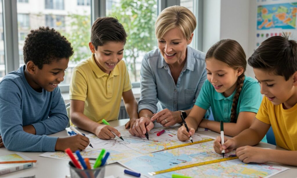
Jr Geo is an innovative educational platform designed to spark children’s interest in cartography and geography. It combines fun with learning, making the world of maps accessible and exciting for young minds.
The program offers interactive activities that engage kids in exploring their surroundings. Through games, puzzles, and hands-on projects, Jr Geo encourages creativity while teaching essential skills like navigation and spatial awareness.
By focusing on age-appropriate content, Jr Geo caters specifically to children’s curiosity about the world around them. This not only helps them understand geography but also fosters a sense of adventure.
With colorful visuals and engaging narratives, Jr Geo turns complex concepts into digestible lessons that inspire future generations. Kids can embark on virtual journeys or create their own maps—making each experience unique.
The Evolution of Cartography and Geography
Cartography and geography have come a long way since ancient times. Early maps were often rudimentary and reflected the limited knowledge of the world. They depicted mythical lands and creatures, serving more as storytelling tools than accurate representations.
With advancements in technology, cartography evolved dramatically during the Renaissance. Explorers ventured into uncharted territories, bringing back invaluable information that reshaped existing maps. The introduction of precision instruments transformed how geographers viewed their surroundings.
The 20th century saw further innovation with satellite imagery and GIS (Geographic Information Systems). These technologies allowed for real-time data collection and analysis, revolutionizing our understanding of landscapes.
Today, digital mapping applications have made geography accessible to all. Maps are no longer static; they’re interactive platforms that continuously evolve based on user contributions and updates. Cartography has shifted from art to science, marrying creativity with technological prowess in profound ways.
The Importance of Teaching Children about Maps and Geography
Teaching children about maps and geography opens up a world of understanding. It helps them make sense of their surroundings and builds spatial awareness.
Maps are more than just tools; they tell stories. Kids learn about different cultures, terrains, and the relationships between places. This knowledge fosters empathy for others who live in far-off locations.
Understanding geography also enhances critical thinking skills. Children navigate through complex information, drawing connections between historical events and geographical features.
Moreover, with technology advancing rapidly, having a solid foundation in geography prepares kids for future careers in various fields like environmental science or urban planning.
Encouraging curiosity about our planet inspires young minds to explore beyond their immediate environment. Each map becomes an adventure waiting to be discovered.
Introducing Jr Geo: A Fun and Educational Tool for Kids
Jr Geo is an innovative platform designed to inspire young minds. It combines learning with play, making geography exciting for kids.
Through interactive maps and engaging activities, children can explore the world like never before. They can identify countries, learn about their cultures, and understand geographical features—all while having fun.
The colorful interface captures attention and encourages exploration. Kids can embark on adventures that stimulate curiosity about their surroundings.
By using Jr Geo, children develop essential skills such as critical thinking and spatial awareness. The tool promotes a love for discovery and nurtures future cartographers.
Whether they’re tracing rivers or marking landmarks, each activity reinforces knowledge in a delightful way. Jr Geo opens up endless possibilities for learning through exploration.
Benefits of Jr Geo for Future Generations
Jr Geo opens up a world of possibilities for young minds. It fosters creativity by allowing children to create their own maps and explore different terrains.
By engaging with geography, kids develop critical thinking skills. They learn to analyze information and make connections between places and cultures.
The interactive nature of Jr Geo keeps them motivated. As they delve into geography, they cultivate a sense of curiosity about the world around them.
Additionally, understanding maps enhances spatial awareness. This skill is vital in daily life, from navigating local neighborhoods to planning future adventures.
With Jr Geo, children gain an appreciation for diversity in landscapes and communities. This awareness promotes empathy as they learn about global challenges and solutions.
These foundational experiences shape informed citizens who care about their environment and each other. The benefits extend beyond education; they impact how future generations interact with the planet itself.
How to Get Kids Interested in Cartography and Geography
Encouraging kids to explore cartography and geography can be a fun adventure. Start by incorporating maps into their daily playtime. Use treasure maps for scavenger hunts, sparking curiosity about locations and directions.
Interactive games that involve mapping can also captivate young minds. Consider using apps or board games that focus on geographic themes. These platforms make learning feel like play rather than work.
Field trips provide real-world experiences that deepen understanding. Visit local landmarks, parks, or museums where kids can connect the dots between what they learn in class and the world around them.
Storytelling is another powerful tool. Share tales of famous explorers or unique cultures to ignite their imagination about different places across the globe.
Encourage them to create their own maps based on favorite stories or adventures they’ve had. This hands-on activity fosters creativity while reinforcing essential skills in navigation and spatial awareness.
Expanding Your Child’s Knowledge with Jr Geo Activities
Engaging your child with Jr Geo activities opens a world of discovery. Kids can embark on exciting treasure hunts, using maps to navigate hidden gems in their own backyard. This hands-on approach turns learning into an adventure.
Crafting personalized maps adds another layer of creativity. Children can illustrate their favorite places and create stories around them, blending art with geography seamlessly. It encourages imagination while reinforcing spatial awareness.
Interactive online games related to cartography are also fantastic tools. They provide stimulating challenges that keep kids entertained while teaching essential skills such as map reading and orientation.
Family outings become educational too! Visiting local parks or historical sites allows children to practice their mapping skills in real time, linking classroom learning with the outside world.
These varied activities help instill a sense of wonder about our planet, sparking curiosity for future exploration and study in geography and cartography.
Shaping the Future of Cartography and Geography with Jr Geo
Jr Geo is more than just a tool; it’s a gateway to the future of cartography and geography. By engaging young minds with interactive maps, kids can explore the world in ways that textbooks simply can’t offer.
The platform encourages creativity and critical thinking. Children learn how to interpret data visually while developing spatial awareness. They gain skills that are crucial for tomorrow’s innovators.
Through collaborative projects, Jr Geo fosters teamwork among peers. Kids share insights and build upon each other’s ideas, making learning dynamic and enjoyable.
As they navigate different terrains, children also cultivate an appreciation for diverse cultures and ecosystems. This understanding lays the groundwork for responsible global citizenship.
With technology evolving rapidly, introducing Jr Geo prepares children for careers that may not even exist yet. It instills a passion for exploration that can lead to groundbreaking discoveries in cartography and beyond.
Conclusion
As we look to the future, it’s clear that nurturing a love for cartography and geography in children is more vital than ever. Tools like Jr Geo play an essential role in this process. They not only make learning enjoyable but also empower kids with knowledge about their world.
By engaging young minds through interactive activities, parents and educators can foster a new generation of geographers and cartographers who are curious, informed, and ready to explore. The focus on maps helps develop critical thinking skills while providing insight into different cultures, landscapes, and environments.
Encouraging exploration through Jr Geo can spark lifelong interests that contribute to understanding global issues such as climate change or urban development. It’s exciting to think about how these budding mapmakers might shape our world tomorrow.
Investing time in teaching children about geography today lays the groundwork for innovators of tomorrow—those who will ultimately navigate the complexities of our planet with skillful precision. Embracing tools like Jr Geo ensures that passion for discovery continues across generations.